


Are Paper maps still a thing? Yes! Imagine a tool that you could hold in the palm of your hand and at a glance see the world around you. Imagine being able to look at detail in all directions and find interesting places to visit. Paper maps can do all of this and more! That is why this guide on how to read a paper road map exists!
Paper maps may seem archaic but they contain so much more information. They can be useful for navigation, finding places or looking at the big picture. The problem is that not everyone knows how to read a paper road map. That’s what this guide is for – to teach you how to find & use a paper map.
Where to find paper road maps
Years ago you could pick up paper road maps at any gas station. The companies that operated the gas stations wanted to encourage road travel so they had all kinds of maps. Sadly, that’s not the case any more. So where can find paper road maps in the 21st century? Just about anywhere.
While you could buy maps on a bookstore or travel store, a better approach is to go to places that have maps of the area. You can start with a tourist information center. This can be a local office or a dedicated center along an interstate or major road way. If you don’t see maps readily, you might have to ask.
Most states will have tourist information centers when you enter them or at least the nearest town will have one. They might have different types of official maps like bicycle route maps or even scenic routes. These places are a great place to pick up a free resource. It’s interesting to note that free maps will gain value over time. Save those official maps!
AAA is another great resource and you can pick up maps before you even leave on your trip. They have state maps as well as regional maps which can be great for planning your trip.
Opening the map up
Most paper road maps come folded to reduce their size. This allows a great deal of information to contained on a very large piece of paper. The first time you use a map, you might want to find a table. That way you can open that map up and orient yourself to it.
Once unfolded and laying flat, look at each side of the map. Most maps have a side that contains the subject matter of the maps title on one side and detailed maps on the other. Start by looking at the larger scale (more on map scales later). Look at roads, streets, highways and the different features. Follow these until you slowly start to figure out where you are on the map.
The Legend
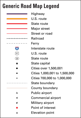
Once you know where you are on the map, look around the map until you find what is called the legend. The legend will tell you a lot of different things about the map. The legend will tell you what each road type is – whether it is an Interstate or limited access highway/freeway, a boulevard, street or road. Some maps might even tell you if a road is paved or not. It will tell you how to distinguish different parks. It will tell you what schools and churches are.
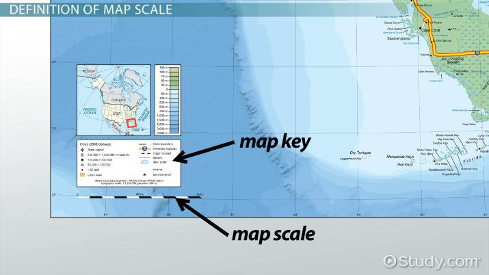
Map Scales
One of the more important things that a legend will have is the maps scale. The scale will tell you how far about things are on the map. For example, without knowing the scale, is 1″ on the map a mile or 20 miles? It’s important to know the scale of the map.
The larger the map scale, the less detail the map will have. A large scale map like 1″=20 miles means they can only fit the detail that they can in that 1″ so not everything within those 20 miles will make the map. A larger scale can also be represented by other numbers such as 1:24,000 or 1:100,000. Just know that the larger the number, the less detail the map will have.
Large Scale = Less Detail Small Scale = More Detail
Planning a Route
Now that we know where we are and what different features are on the map, we can plan a route to where we want to go. Start by finding your destination or the first place that you want to stop.
Once you’ve located where you are going, look for major roads near you that head in the direction where your first stop is. Interstates or limited access freeways are your best bet because they don’t have traffic lights. Traffic lights can add 1-3 minutes every cycle so it’s best to avoid them. Try and find a combination or single road that can take you to your stop.
Once you’ve found a system of roads, orient the map so you know how to start on your route. Once we have that we can get started.
Using the map enroute
Folding the map
Before we start going to our destination, you should fold the map to allow you to quickly look at it if you need to make adjustments. The easiest way to do that is to find a center point between your starting point and destination and then fold in all the foldable sections that are outside of this zone. Start with the narrow sections on the left and right and then fold down the larger sections on the top and bottom. If this section is still too large, fold the map in half so you can flip it over when you are half way. You might also find that even that is too big if you’re on a very long try so just fold it so it is a reasonable size and unfold it as you make stops.

Along the way you can pick up the folded map and see where you are relative to your destination and places you might see along the way. Let’s say you’re travelling down an interstate and you need a rest area. You could wait for a blue “Rest Area” sign to show up but you can also look at your map and see when the next one will be. You can also see where larger towns are along your route if you’re looking for food or lodging.
Driving tips with the map
In an urban area, it might be best to either have a passenger help guide you or supplement the directions you obtained earlier by using a GPS or other wayfinding tool. The map will still give you the larger picture and you can always reference it at traffic lights but at least you’ll have it to keep the GPS honest and on a safe route.
The map can tell you all kinds of information like how far it is to the next larger town or how much further you have until you’re outside of the city. It can tell you what exit you need if you want to stop at one of these places and it can tell you where you can find places of interest along the way.
Using GPS or Waze with your paper map

You might think that you have to use either a paper map or an electronic map for your navigation but that’s not the case. Using both gives you information like exactly how far it is to your destination or the best route to take to avoid traffic. Waze is the best app for that but it’s also good to have a paper map because sometimes those tools will take you a certain way just because a calculation shows it as being 1 minute faster than another. The problem is, it doesn’t take traffic lights or the fact that you might get stuck behind a slow truck into consideration. A GPS can’t tell you how long it is until the next rest area while a paper map can.
While you can pull up some information but it’s also a lot easier to lift up a map and find a place to stop before your destination. You can also use the map to check to see if the route you’re on makes sense. Why drive 30 miles out of your way just the interstate has a higher speed limit when you could take a straight road to your destination at a lower speed? Having a paper map can save you that time and money and provide you with more information along the way.
Conclusion
Hopefully this guide has helped you learn how to read a paper map. The combination of modern tools does not make using a paper map obsolete. Rather it makes using one a strong tool for getting safely and comfortably from point A to point B.
If you are looking to hit the road, but sure to check out our guides for RV’s and for getting great prices on hotels!


